
The Wabanaki people have a wealth of creation myths that explain the rocky shores of the Bay of Fundy, Downeast Maine, and Acadia National Park. Many involve Glooscap, a magical figure said to have floated around the Bay of Fundy in a stone canoe, sculpting coastal features by scraping the boat across the landscape and
The Wabanaki people have a wealth of creation myths that explain the rocky shores of the Bay of Fundy, Downeast Maine, and Acadia National Park. Many involve Glooscap, a magical figure said to have floated around the Bay of Fundy in a stone canoe, sculpting coastal features by scraping the boat across the landscape and scattering huge boulders during battles with primordial beavers, frogs, moose, whales and other giant animals.
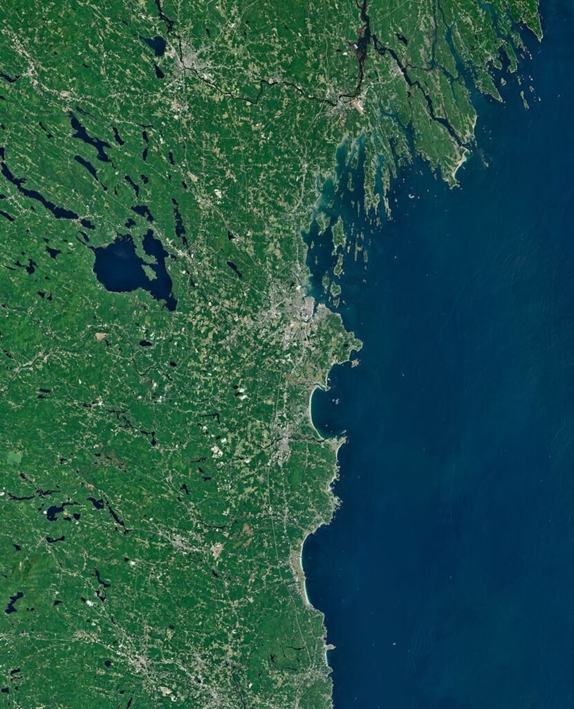
Fewer indigenous creation myths survive to explain the origins of the sandy, swampy shores of southern Maine and the rocky, rugged shores of the state’s midcoast region. But the stark contrast between the sandbars and beaches south of Portland and the rocky coast of headlands, promontories and narrow peninsulas to the east (visible in the Landsat image above) has long attracted the attention of coastal geologists, whose scientific explanations for their origins abound.
The coastal transition reflects both differences in the underlying bedrock and the distribution of sediments left behind by the Last Glacial Maximum, coastal geologists say. Southern Maine has extensive deposits of sand, much of it coming from rivers. The sandy beaches of Saco Bay, for example, home to Maine’s longest contiguous beach and the state’s largest salt marsh, received sediment from the erosion and decay of the White Mountains, with the material transported to the coast largely by the Saco River, explained Peter Slovinsky, a geologist with the Maine Geological Survey. Waves and tides reshaped these soft sediments over time, sculpting them into the arc-shaped bay beaches and extensive salt marshes found around Saco Bay and the broader region.
While erosion-resistant granite protrudes from the sandy shores of southern Maine to form rocky promontories, metamorphic bedrock becomes the dominant surface feature east of Portland. There, entire ridges and valleys formed by layers of rock transformed by exposure to high pressures and temperatures define the landscape. During the last ice age, glaciers swept away and widened many of these coastal valleys, which were then flooded when the Laurentide Ice Sheet melted and sea levels rose.
Around Casco Bay, these ridge and valley systems, combined with coastal subsidence, produce the irregular, highly indented coastline and many long, narrow islands seen today. “The tortured folds of these old landscapes also established a strong directional preference for erosion to exploit,” said Nicholas Whiteman, also a geologist with the Maine Geological Survey. “This led to a striking difference in the orientation of the islands and necks dominating Casco Bay compared to those to the northeast.”
The various shapes that coastlines take fascinate geologists, but they also have everyday implications for the economies of Maine’s coastal communities. While tourists flock to the sandy beaches of communities like Saco and Kennebunkport, the state’s iconic lobster fisheries are concentrated on Maine’s central coast. The crustaceans thrive in the cold waters of the region’s many rocky, sheltered inlets, making communities like Harpswell leaders in lobster landings.
The state’s oyster farms are also concentrated in this region. Casco Bay and the Damariscotta Estuary, protected from winds and waves, offer waters that farmers can easily access without large boats. These waters provide a variety of temperatures, salinities and other characteristics that create numerous microclimates where oysters can grow rapidly and take on a variety of flavors, known as merroir, explained Tom Kiffney, a researcher at the University of Maine. Kiffney is part of a team of researchers using Landsat and other satellite observations to predict oyster growth rates and help identify the most promising locations for new oyster farms in Maine based on temperature and water quality.
NASA Earth Observatory image by Michala Garrison, using Landsat data from the US Geological Survey. Story by Adam Voiland.

- Kelley, J. (1987) Coastal environment inventory and classification of the Maine glacial coast. Glaciated Coasts, 151-176.
- Kiffney, T., et al. (2026) Using dynamic energy budget models and high-resolution satellite products to predict eastern oyster growth at the farm scale. Aquaculture612(1), 743133.
- Leland, C. (1884) Algonquin Legends of New England: How Glooskap Sailed Through the Great Cavern of Darkness. Accessed July 17, 2026.
- Maine.gov (2026) Maine Coastal Marine Geology. Accessed July 17, 2026.
- Maine Geological Survey (2002) Simplified bedrock geologic map of Maine. Accessed July 17, 2026.
- Maine Geological Survey (1999) The variety of Maine’s changing coast. Accessed July 17, 2026.
- Merroir (2026) What is Merroir? Accessed July 17, 2026.
- NASA (2026, January 15) NASA data helps Maine oyster farmers choose where to farm. Accessed July 17, 2026.
- NASA Earth Observatory (2017) Prospecting for oysters with Landsat 8. Accessed 17 July 2026.
- Snyder, J., et al. (2017) Site selection for oyster aquaculture using sea surface temperature, turbidity and chlorophyll derived from Landsat 8 a. Frontiers in marine sciences4(190).
- World History Encyclopedia (2025, February 6) Glooscap Tales. Accessed July 17, 2026.
Keep following us for the latest insights.