
Benjamin SchäferRare Technologies, Inc. We propose a new approach for atmospheric sensing at altitudes of 30 to 100 km using photophoretically levitating tracers. These lightweight structures take advantage of sunlight to remain suspended for up to months at controlled altitudes and can be tracked remotely using lidar or satellite radar. Unlike natural sprays, these tracers
Benjamin Schäfer
Rare Technologies, Inc.
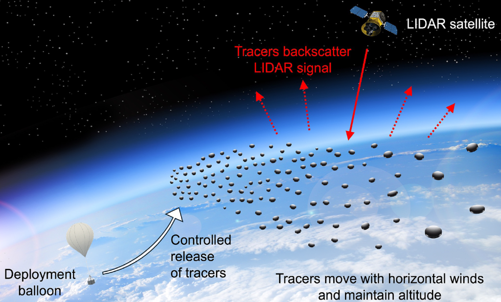
We propose a new approach for atmospheric sensing at altitudes of 30 to 100 km using photophoretically levitating tracers. These lightweight structures take advantage of sunlight to remain suspended for up to months at controlled altitudes and can be tracked remotely using lidar or satellite radar. Unlike natural sprays, these tracers are designed to provide a strong signal and tunable backscatter at standard remote sensing wavelengths, enabling passive, persistent and altitude-selective measurements of wind, temperature and pressure in a region that is critically underframed by existing systems.
This concept addresses a major gap in current detection capabilities. The mesosphere and upper stratosphere play a key role in atmospheric dynamics, space domain awareness, space weather, and navigation on high-altitude platforms. Despite the importance of this region, data collection remains a challenge. Near space is too high for sustained balloon flight and too low for satellites to be in orbit. Concentrations of existing atmospheric species are also too low for remote sensing techniques such as lidar and radar. Photophoretic tracers offer a new solution: a stratified, persistent sensing layer of inert, non-toxic backscatter spots that require no power, propulsion, or onboard control. These tracers can be deployed by high-altitude balloons or rockets and autonomously reach their target altitudes based on their geometry and coatings.
In a representative mission, thousands of tracers are launched from a light balloon at about 30 kilometers. The tracers rise to their target altitude of 90-100 km, the lower ionosphere. The satellite-based lidar tracks its movement over its month-long lifespan. Tracer trajectories allow wind shear, thermal gradients and pressure profiles to be continuously mapped at sub-kilometer resolution and hourly cadence. Data collected in real time are used to calibrate the boundary conditions of ionospheric space weather models. As more data is collected, the predictive capabilities of these models improve, leading to greater situational awareness and resilience of near-space and LEO communications. Other early deployments could, for example, support improvements to weather models in the tropics and monitor atmospheric conditions at spaceports.
This work is based on emerging experimental results in photophoretic flight, with laboratory validation of levitation in near-space conditions and initial simulations of tracer scattering and visibility. Backscatter models confirm the feasibility of orbital detection using commercially available lidar systems. The tracers are designed to disintegrate safely at the end of their useful life and are compatible with scalable manufacturing techniques. By designing the dispersion medium itself, this concept reverses traditional atmospheric remote sensing. It enables lower SWaP-C satellite sensing systems and a fundamentally new class of persistent measurement tools for national security, meteorology, heliophysics, and planetary exploration.
National Teams 2026
Check back often for more exciting news!